In exercise of the power conferred by section 2 of the Merchant Shipping Ordinance 1952, The Minister defines, with effect from the 1st September 1994, the following limits as near coastal trade voyages limits:
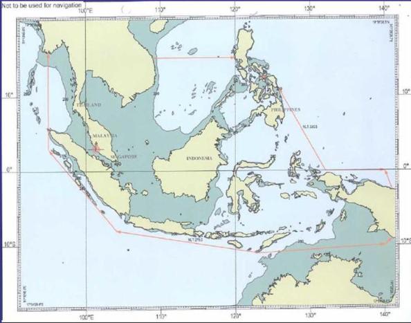
Comencing from point on the coast of Myanmar where the longitude 95 00' Esat meets the Myanmar Coast; thence proceeding south along Longitude 95 00' East till it meets a point at Latitude 3 00' North; thence proceeding south-easterly to a point at Latitude 8 00' South Longitude 104 00 East; thence proceeding southh-easterly to a point at Latitude 11 00' South Longitude 123 00' East; thence proceeding north-easterly to a point at Latitude 10 00' South Longitude 140 00 East; thence proceeding north-easterly till it meets the southern teritorial boundary of Indonesia and Papua New Guinea; thence proceeding along the coast of Irian Jaya till it meets the northern territorial boundary of Indonesia and Papua New Guinea; thence proceeding north-westerly to a point at latitude 0 00' North Longitude 140 00' East; thence proceeding west to a point at latitude 0 00' North Longitude 132 00' East; thence proceeding north-westerly till it meets the southern-most tip of Samar Island in Philipines; thence proceeding along the west coast of Samar Island northwards til it meets the north-westernmost tip of the said island; thence crossing the San Bernardino Strait to the sounthernmost tip of the Luzon Island; thence proceeding along the west coast of Luzon Island northwards till it meets a point at Latitude 15 00' North; thence proceeding westwards along the Latitude 15 00' North till it meets the Coast of Vietnam; thence proceeding south along the coasts of Vietnam, Kampuchea, Thailand, Peninsular Malaysia, Singapore , Peninsular Malaysia, Thailand and Myanmar, returning to the point of commencement.
The above limits shall include all waters including rivers within the limits navigable by sea-going ships.