ROUTEING SYSTEM
The International Maritime Organisation (IMO)
is recognised as the only international body responsible for establishing and
recommending measures on an international level concerning ship's routeing.
The purpose of ship's routeing is to improve the safety of navigation in converging areas and in areas where the
density of traffic is great or where freedom of movement of shipping is inhibited by restricted sea-room, the existense
of obstructions to navigation, limited depths and unfavourable meteorological conditions.
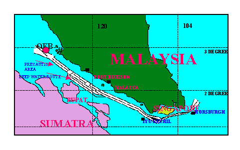
Traffic Separation Scheme
- A routeing measure aimed at the separation of opposing streams of traffic by appropriate means and by establishment of traffic lanes.
Separation zone and lines
- A zone or line separating the traffic lanes in which ships are proceeding in opposite or nearly opposite directions; or
separating a traffic lane from the adjacent sea area; or separating traffic lanes designated for particular classes of ship
proceeding in the same direction.
Traffic lane
- An area within defined limits in which one-way traffic is established. Natural obstacles, including those forming
separation zones, may constitute a boundary.
Inshore traffic zone
- A routeing measure comprising a designated area between the landward boundary of a traffic separation scheme and the
adjacent coast, to be used in accordance with the provision of Rule 10(d), as amended, of the International Regulations for
Preventing Collision at Sea, 1972 (Collision Regulations).
Deep-water route
- A route within defined limits which has been accurately surveyed for clearance of sea bottom and submerged obstacles as
indicated on the charts.
Precautionary areas
- A routeing measure comprising an area within defined limits where ships must navigate with particular caution and within which the
direction of traffic flow may be recommended.